Select NOAA-NWS Forecast Office Text Products
(Product availability varies with seasons, forecast office, and weather.)
Hazardous Weather Outlook for Omaha, NE
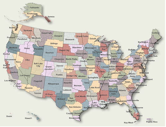
To Select Another NWS Office Click on Map or Choose from List
Select Forecast Office:
Birmingham
Huntsville
Mobile
Anchorage
Fairbanks
Juneau
Flagstaff
Phoenix
Tucson
Little Rock
Eureka
Hanford/San Joaquin Vly.
Los Angeles
Sacramento
San Diego
San Francisco
Denver/Boulder
Grand Junction
Pueblo
Jacksonville
Key West
Melbourne
Miami
Tallahassee
Tampa Bay Area
Atlanta/Peachtree City
Tiyan
Honolulu
Boise
Pocatello
Lincoln
Chicago
Indianapolis
Northern Indiana
Des Moines
Quad Cities
Dodge City
Goodland
Topeka
Wichita
Louisville
Paducah
Lake Charles
New Orleans
Shreveport
Caribou
Portland
Baltimore/Washington DC
Boston
Detroit
Gaylord
Grand Rapids
Marquette
Duluth
Minneapolis
Jackson
Kansas City
Springfield
St. Louis
Billings
Glasgow
Great Falls
Missoula
Hastings
North Platte
Omaha
Elko
Las Vegas
Reno
Mt. Holly/Phyladelphia, PA
Albuquerque
Albany
Binghamton
Buffalo
New York City/Upton
Newport/Morehead City, NC
Raleigh/Durham
Wilmington
Bismarck
Grand Forks
Cleveland
Wilmington/Dayton
Norman
Tulsa
Medford
Pendleton
Portland
Philadelphia/Mt. Holly, NJ
Pittsburgh
State College
San Juan
Charleston
Columbia
Greenville/Spartanburg
Aberdeen
Rapid City
Sioux Falls
Knoxville/Tri Cities
Memphis
Nashville
Amarillo
Austin/San Antonio
Brownsville
Corpus Christi
Dallas/Fort Worth
El Paso
Houston/Galveston
Lubbock
San Angelo
Salt Lake City
Burlington
Roanoke/Blacksburg
Wakefield
Seattle/Tacoma
Spokane
Charleston
Green Bay
La Crosse
Milwaukee
Cheyenne
Riverton
Select Product:
Forecast Discussion
Air Quality Alert
Hazardous Weather Outlook
Public Information Statement
Daily Hydrometeorology
Regional Weather Summary
Short Term Forecast
Non-Precip. Wrn./Wtch./Adv.
Flash Flood Statement
Flood Warning
Local Storm Report
Mean Areal Precipitation
Regional Min/Max Temp & Precip
Recreational Forecast
Winter Storm Wrn./Wtch./Adv.
WFO Monthly Report- Preliminary
NWS Hazardous Weather Outlook for Omaha, NE currently not available.
Products Courtesy of NOAA-NWS Saratoga Weather - WFO and Products Scripts by SE Lincoln Weather .Michiana Weather and by Tom at My Mishawaka Weather .

 Scan With Phone's Bar Code Reader