No Warnings, Watches, or Advisories
Regional Radar
Radar Images Courtesy of Radar Monster and GEOCOLOR Satellite Images Courtesy of NESDIS.
spacer
METRIC | IMPERIAL
Updated: 23-Apr-2024 @ 1:15 AM  
Temperature Current Conditions4 Forecast / 2 Hr. Lightning
Currently Outside: Colder 1.3°F than last hour.

60.1°F

---
High Today
61.9°F
12:00 AM
Low Today
60.1°F
1:08 AM
Yest High
77.8°F
4:42 PM
Yest Low
46.4°F
2:47 AM
Sta* High
87.9°F
2009
Sta* Low
25.5°F
2023
* This Station's Records Since 2008
Rec** High
89°F
1921
Rec** Low
21°F
2023
Avg** High
67°F
Avg** Low
42°F
** Records from NOAA
Night time, Dry, Partly cloudy Night time, Dry, Partly cloudy

Wind from NE Wind:  NE
1.3

Gusting to:
2.0 mph
Current Rain Rain:
0.00 in
Overnight

Overnight: Chance Showers And Thunderstorms
Chance Showers And TStorms
Tuesday

Tuesday: Slight Chance Rain Showers then Mostly Sunny
Slight Chance Rain Showers then Mostly Sunny
Tuesday
Night
Tuesday Night: Mostly Clear
Mostly Clear
Lo 50°F Hi 71°F Lo 38°F
2 Hr. Lightning Map Unavailable
Dew Point Liquid Precipitation Wind Speed Sun/Moon
Current: Increased 0.5°F since last hour. 47.5°F
Last Hour: Increased 0.5°F since last hour. 0.5°F
High 12:58 AM: 49.2°F
Low 12:02 AM: 45.1°F
Record High: 84.0°F on
21-Aug-2023
Record Low: -24.7°F on
16-Feb-2021
Wetbulb: 53.6°F
Rain Today
rain graph

Today: 0.00 in
Yesterday: 0.00 in
Last 7 Days: 0.60 in
Apr Rain: 1.01 in
Apr to Date
  Avg:10
1.75 in
Apr to Date
  Diff from Avg:10
Under 0.74 in for the month 0.74 in
Apr Avg: 2.56 in
Diff from Avg: Under 1.55 in for the month 1.55 in
Season:1 3.230 in
YTD
  Avg:11
4.25 in
YTD
  Diff from Avg:11
Under 1.02 in for the year 1.02 in
Last Rain
Date/Time:
16-Apr-2024
at 3:20 PM
15 rain days in 2024
3 days in April
6 days since last rain
Current: NE  1.3 mph
1Hr Average: 0.4 mph
Wind Run: 0.52 miles
Wind Gust
Current: 2.0 mph mph
Today: 4.0 mph 12:12 AM
Month: 39.0 mph 6-Apr
Year: 39.0 mph 6-Apr
Record Gust: 48.0 mph
24-May-2008
Sunlight:
13 hrs 40 min
27 sec
of Sunlight Today
Which is
2 min 29 sec longer than
yesterday
(Noon) graph (Midnight)
Legend

Waxing Gibbous
Waxing Gibbous, 14 days, 12 hours, 9 minutes in cycle
100%
Illuminated
Humidity Barometer
Current: Increased 4% since last hour. 63%
Last Hour: Increased 4% since last hour. 4%
High 12:57 AM: 66%
Low 12:02 AM: 54%
Record High: 100%
4-Feb-2008
Record Low: 0%
20-Aug-2017
Current: Rising 0.018  inHg/hr 29.772 inHg
Last Hour: Rising slowly
High 12:04 AM: 29.807 in.
Low 12:12 AM: 29.753 in.
Record High: 31.234 inHg
7-Jan-2015
Record Low: 26.899 inHg
18-Mar-2024
Heating Degree Days WebCam Thumbnails Wind Chill Air
Today: 0.1
Apr: 227.9
2024 to Date: 2774.5
Cooling Degree Days
2024 to Date: 21.3
PatioCam PatioCam Image facing North
StreetCam StreetCam Image facing South
Current: 60.1°F
Low 1:08 AM: 60.1°F
Yesterday: 40.6°F
Record: -37.3°F
22-Dec-2022
Quality
Index6:

35


Good
Density:
1.21 kg/m3
US AQI
UV Summary/Forecast Solar Summary
High Yest:   4.2 @ 12:50 PM
Apr-23

5.8
Apr-24

6.1
Apr-25

6.9
High Yest:   881.0 @ 11:43 AM
Sun Hours Today:
00:00
   This Month: 116:54 Hrs
Rise: 6:34am  Set: 8:15pm
SE Lincoln WX Almanac Irrig. Index5 Station All Time Records Cloud Level
Currently: Night
YTD Avg Temp: 40.6°F
Sunrise: 6:34am
Sunset: 8:15pm
Moonrise: 7:20 pm
Moonset: 6:19 am
Full Moon: 23-Apr-2024
New Moon: 10:23 PM CDT
7-May-2024
Updated at Midnight
Current ET: 0.03 in
7-Days Rain: 0.60 in
7-Days ET: 1.02 in
7-Day:  0.416 in water in deficit of what evaporated in last 7 days. 0.416 in
April:  2.39 in water in deficit of what evaporated this month. 2.39 in
Season Countdown
Summer
Begins:
3:51 PM CDT
20-Jun-2024
 
HIGHS: LOWS:
106.9°F
24-Aug-2023
-19.8°F
16-Feb-2021
Daytime Records
  106.0°F
15-Jun-2016
  -8.7°F
14-Jan-2024
Nitetime Records
  91.0°F
25-Jul-2012
  -12.8°F
16-Feb-2021
ICN:4 | S3C2:0 | Ajax 3.xx
ISS:Ok | CON:3.4 | RCP:98%
METRIC | IMPERIAL
Updated: 23-Apr-2024 @ 1:15 AM  
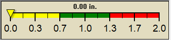
1 Rain season: Jan 1st to Dec 31st.   4 Chandler Burning Index (CBI) Updates Continuously.   5 Estimated amount of water needed to replace the water used by plants and evaporation from the past week. (Negative numbers mean amount of water needed, positive numbers mean excess water is present).   6 Air Quality Index is provided by Douglas County Health Department in Omaha, NE. AQI Data for Lincoln, NE is currently unavailable as an RSS feed..   10 Historical average only to day 23 of just the month of April for this station since 2008.   
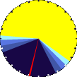
11 Historical average rain this season to day 23 of April for this station since 2008.
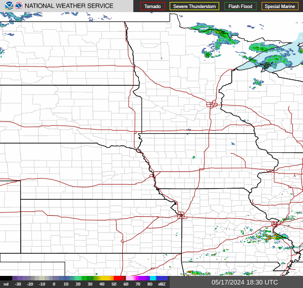
 NWS Weather Forecast  -   Outlook Overnight & Tuesday
Overnight

Overnight: Chance Showers And Thunderstorms
Chance Showers And TStorms

Lo 50°F
NWS forecast: A chance of rain showers before 1am, then a chance of showers and thunderstorms. Mostly cloudy. Low around 50, with temperatures rising to around 52 overnight. Northeast wind around 6 mph. Chance of precipitation is 50%. New rainfall amounts less than a tenth of an inch possible.
WXSIM forecast: Partly to mostly cloudy. Low 53°. Wind north near calm.
Tuesday

Tuesday: Slight Chance Rain Showers then Mostly Sunny
Slight Chance Rain Showers then Mostly Sunny

Hi 71°F
NWS forecast: A slight chance of rain showers before 7am. Mostly sunny, with a high near 71. North northwest wind 6 to 18 mph, with gusts as high as 28 mph. Chance of precipitation is 20%. New rainfall amounts less than a tenth of an inch possible.
WXSIM forecast: Partly to mostly cloudy in the morning, becoming sunny in the afternoon. Breezy. High 69°. UV index up to 7. Wind north around 9 mph, gusting to 22 mph, in the morning, becoming 15 mph, gusting to 25 mph, in the afternoon.
 NWS Short Term Weather Forecast
Tuesday
Night
Tuesday Night: Mostly Clear
Mostly Clear
Wednesday

Wednesday: Mostly Sunny
Mostly Sunny
Wednesday
Night
Wednesday Night: Slight Chance Rain Showers
Slight Chance Rain Showers
Thursday

Thursday: Chance Rain Showers
Chance Rain Showers
Thursday
Night
Thursday Night: Showers And Thunderstorms
Showers And TStorms
Friday

Friday: Showers And Thunderstorms
Showers And TStorms
Friday
Night
Friday Night: Showers And Thunderstorms then Chance Showers And Thunderstorms
Showers And TStorms then Chance Showers And TStorms
Lo 38°F Hi 68°F Lo 50°F Hi 71°F Lo 58°F Hi 79°F Lo 53°F
Season Countdown Timer by Curly
Precipitation average-to-date script courtesy of Murry Conarroe
ajax-dashboard.php - Version 1.32 - 18-Jan-2023 - Multilingual - Script by: Scott of BurnsvilleWeatherLIVE.com
Now supported by Saratoga-weather.org Download